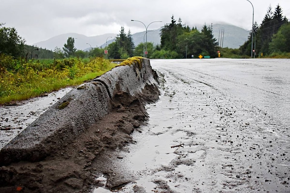
Torrential rainfall caused flash flooding across Hwy 16 at the Prince Rupert and Port Edward turn off on Aug. 15, creating dangerous driving conditions and leaving silt and debris strewn across the road surface.
Do not put your rain gear away Prince Rupert, said Environment Canada. The heavy rains are not over yet, with rainfall over Aug. 14 to 15 expected to be more than the total monthly average, Bobby Sekhon meteorologist with Environment and Climate Change Canada, said.
“It’s been a wet summer and the ground has probably taken on quite a bit of moisture,” Sekhon said. “It’s hard to say what is going to come out for impacts of this heavy rainfall, but there’s the possibility of local flooding and basic slope instability.”
The expected rain fall could be well above the monthly average for August, which historically is 169 mm. Sekhon said the unofficial numbers for the mid-month point are at 114 mm, with weekend rain expected to bring more than 150 mm in just two or three days.
READ MORE: Heavy rainfall warning, Rainfall expected to exceed 100 mm in Prince Rupert and North Coast regions
“Along the north coast we usually expect more of the heavier precipitation than inland sections in these cases. We have seen this consistent pattern of these low pressure systems coming through the Gulf of Alaska. That has really taken aim at the North Coast and Alaska Panhandle for heavy rain. So we have seen many rounds of that same pattern come through.”
The summer months are usually the driest of the year along the North Coast and Prince Rupert, Sekhon said. June is the driest month with an average of 109 mm of precipitation, followed by July with 119 mm. However, this past July saw almost double the rain fall with 204 mm and June had 132 mm.
“One thing we can look back at … when we had the wildfires a couple of years ago, in the Bulkley Valley and the Lakes District, that was indicative of the drier pattern in those years. Most of the systems that enter those areas pass through the North Coast. In talking to some people in the North Coast, they are saying this year has been wetter than in the past.”
READ MORE: Cold snaps all weather records in Prince Rupert
This summer Prince Rupert is experiencing an ‘atmospheric river’, which is a term used to describe multi-day heavy rain off the Pacific ocean.
“We are not seeing very high temperatures. Temperatures are pretty cool for this time of year and are struggling to meet average. In that sense it is not a super warm stream of moisture,” Sekhon said.
“As meteorologists, our focus is the next seven days and the highest confidence is within 48 hours. We can apply our meteorology skills, our diagnoses, our prognoses, we can look at all the different formation we have, including satellite and ground observation and then incorporate that with our numerical models that computers generate.”
“We are seeing things subside somewhat on Sunday. Rain will taper off on Sunday, and we can hope for a bit of a drier period … We are not expecting an atmospheric river during the week, however it will be still be unsettled … as we get into late next week we can see another round of heavy rain. It is still several days off so it’s hard to say with confidence but we are tracking it.”
K-J Millar | Journalist
Send K-J email
Like the The Northern View on Facebook
Follow us on Twitter
“