Grand ideas and abstract concepts are finally beginning to take shape in the long process to redesign the city of Prince Rupert, first initiated by mayor and council in late summer 2015.
Hours and hours of consultation with the public through the Redesign Rupert process and dozens of meetings have partly led up to this past week, where the City of Prince Rupert retained the services of The Planning Partnership to come to town.
The Toronto-based firm has provided designs to cities and towns all over the country, including many with waterfronts similar to Prince Rupert’s.
From Nov. 21 to Nov. 24, four representatives from The Planning Partnership toured the city and talked with city council, city staff, business leaders and the public about how to revitalize Third Avenue, Seal Cove and city-owned waterfront lots.
What they researched and subsequently designed is a master plan for many areas of Prince Rupert — one that includes an overall desire to knit the downtown and waterfront together.
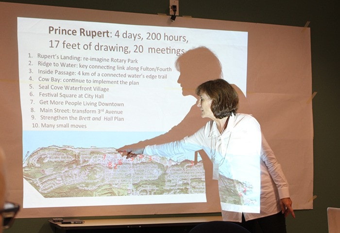
The team didn’t submit a report but provided a 17-foot map accompanying points of interest with written details on the changes that may be implemented.
These are just the designs however, as funding for all these projects has yet to be identified.
“The work doesn’t stop here. We’re going to be giving everything we’ve done to the municipality and have it printed and distributed in the community as much as possible,” said Planning Partnership partner Donna Hinde in a presentation to the public on Nov. 24.
“This is just the very beginning.”

10-POINT PLAN
1) Rupert’s Landing: re-imagine Rotary Waterfront Park
2) Ridge to Water: connecting link on Fulton/Fourth
3) Inside Passage: 4km of connected water’s edge trail
4) Cow Bay: continue to implement the plan
5) Seal Cove Waterfront Village
6) Festival Square at City Hall
7) Get More People Living Downtown
8) Main Street: transform Third Avenue
9) Strengthen the Brett and Hall Plan
10) Many Small Moves
RUPERT’S LANDING
A new waterfront space called Rupert’s Landing at Rotary Waterfront Park was first on the docket for The Planning Partnership. The plan would involve building a new dock where the airport ferry landing would re-locate, a kayak launch, a boat tie-up space, a re-purposed train station and event space, with parking and trail options. The historical train terminal building may also be re-purposed.The building could house offices for Adventure Tours, who are looking to relocate to the area within the new pier. Space would be constructed for the public to access the water, with negotiations ongoing with CN. Public seating was also promoted with sliding chairs utilized along old, unused rail lines.
“The proposition here is to reconfigure the water’s edge, as this new pier is constructed, as the ferry dock is constructed, to create a space where you can step down to the water’s edge,” said David Leinster, partner with The Planning Partnership, adding that encouraging private property owners along the waterfront to open their space publicly is a necessary step to change mindsets in being more open.
“In most cities we work with it’s about connecting the downtown to the waterfront, especially when you have an amazing one like you do here.”

RIDGE TO WATER
The Ridge to Water plan includes implementing a staircase leading to the parking lot area of Rupert Square Mall from the new pier and through Fourth Street and Fulton Avenue to a new plaza at City Hall and beyond leading to Northwest Community College.
An Inside Passage Trail was also promoted. This four kilometre trail network leads from Rupert’s Landing to Seal Cove, with distance markers on the trail, multiple trail entries, seating, shelters and lookouts (pavilions) and interpretive signage.
In Cow Bay, the designers liked the Port of Prince Rupert’s master plan for the area already (outlined earlier this year to council).
“We think [the plan] is quite appropriate to create additional small scale infill development that would continue the type of function that Cow Bay is currently – which is an eclectic mix of tourism, restaurants and shops in a very pedestrianized environment – kind of like Granville Island. The cars and people and bikes – they mix and negotiate and people kind of figure it out,” said Mike Hudson.
A connecting road between Third Avenue and George Hills Way is also in the plans, leading heavy traffic away from Cow Bay.
SEAL COVE
In Seal Cove, the planners are encouraging a mixed use space, enhancing the commercial activity there, installing a big long wharf extending out into the lagoon, as an iconic image, that can be rented out to marine or aerial businesses, similar to the old train station building at Rotary Waterfront Park. Float houses were proposed to surround the building to create a small village. Public parkland was encouraged, as was a corner store in the area to create a sense of community.
CITY HALL
At City Hall, rather than gardens and parking lots surrounding the building, The Planning Partnership suggested creating a destination space as a festival square idea where the community can watch basketball games on a big screen or set up temporary market vendors or an artists’ alley at night.
“Think of it as an active social space for everyone to gather, but it’s also great during the day as a civic square,” said Leinster.
Canopies could be installed on each end of City Hall, lit at night and providing shelter from the rain. The entire area from the businesses across the street from City Hall to the space behind it would be repaved as ‘tabletop paving’, which can be closed off for big events and more pedestrian-friendly.
Vehicles would move slower through the area, acknowledging that it’s very much a pedestrian space when there are events, and the street would function normally when there are no events.

THIRD AVENUE
Transforming Third Avenue involves reducing the perceived width of the road from 14 metres to seven and implementing trees and small garden patches in curb bump-outs. Sidewalks would be increased by a metre on either side and movable planters and benches would also be installed, having city life spill into the streets with cafe areas and retail signage.
“Fundamentally what we’re looking to do is reduce the vehicular footprint and enhance the pedestrian environment,” said Brett Hoornaert.
Instead of curbs, the entire streetscape would be one level material – flex-space.
Cycling lanes were proposed for the rear alleyways instead of reducing the sidewalk width on Third Avenue. In the vacant lots on Third, temporary pop-up cafes and vendors, possibly utilizing things like storage containers, were proposed, all with an emphasis on installing more greenery wherever possible on the street.
The partners also encouraged more downtown residential areas, not displacing existing residents, but looking at undeveloped lots with buildings no taller than the upper terrace. Above grade parking was approved if lined with retail space. Ground floor retail space was considered ideal as was infilling Third Avenue with residential buildings to get more people living downtown.
Roundabouts were proposed in intersections in front of the courthouse and at Five Corners.
“We want to produce a giant poster of all this work and make sure it’s out in the community ... It should be accessible and top of mind,” said Hinde.