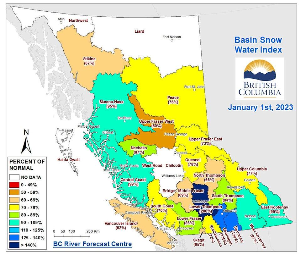
Snow levels are well below normal in most parts of British Columbia, but the snow levels in the Boundary and Okanagan basins are higher than usual.
According to the most recent Snow Survey and Water Supply Bulletin, from the B.C. River Forecast Centre, the average Jan. 1 snow measurements across the province are at 82 per cent of normal.
The Upper Fraser West basin is at 50 per cent of normal, the Vancouver Island basin is at 62 per cent of normal and the Skagit basin is at 65 per cent of normal.
READ ALSO: Summerland’s snow levels significantly higher than normal
READ ALSO: Cold, snowy ‘chaos’ over but lots of winter still to go in the Okanagan, expert says
“Extended cold, dry weather in November and December limited snow accumulation in the mountains,” the executive summary of the report stated. “Below normal snow basin indices are an early indicator for potential spring or summer drought concerns for some regions.”
By Jan. 1, nearly half of the seasonal snow pack has accumulated, on average. However, with three or more months left for snow accumulation, the seasonal snow pack levels can still change considerably.
While snow levels are lower than normal in most areas, the Boundary and Okanagan regions both have snow measurements significantly higher than normal. In the boundary region, the snow level is 129 per cent of normal, while in the Okanagan, the level is 135 per cent of normal.
The Lower Thompson, within the Middle Fraser sub-basin, was at 200 per cent of normal levels.
Nearby, the Similkameen basin is just 72 per cent of its normal levels.
At the Summerland Reservoir, the snow station recorded an all-time high record for Jan. 1, at 197 per cent of normal measurements, based on 58 years of records.
Significant drought conditions were experienced throughout the province from the summer and into the fall in 2022. September and October were much warmer than normal and also unusually dry.
In late October and early November, several atmospheric rivers brought storms to coastal British Columbia.
In December, temperatures were -8.0 to -1.0 C colder than normal.
The beginning of January has been drier than normal.
This year is the third consecutive La Niña year in the province. La Niña conditions tend to create cooler conditions in British Columbia and wetter conditions on the province’s south coast and on Vancouver Island in winter.
To report a typo, email:
news@summerlandreview.com.
news@summerlandreview.com
Like us on Facebook and follow us on Twitter.
