Tsunami Preparedness week runs from April 10 to 16, with Prepared BC and the City of Prince Rupert wanting to raise awareness of proper procedures in such an event by hosting a virtual hiking contest.
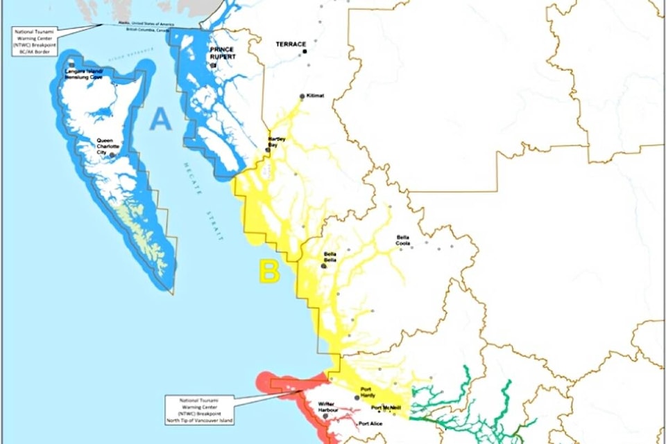
“Our coastal communities are divided into five tsunami notification zones. Knowing your zone will help when a warning, advisory or watch is issued for your area,” Preparedness BC stated on their website.
Prince Rupert and Haida Gwaii fall under zone 1 under the banner of Kitimat-Stikine Regional District and ] Skeena-Queen Charlotte Regional District. Communities in these districts are Alice Arm, Gingolx, Gitxaala (Kitkatla), Hunts Inlet, Kitsault, Lawnhill, Lax Kw’alaams, Masset, Metlakatla, Old Masset Village Council, Oona River, Port Clements, Port Edward, Port Simpson, Prince Rupert, Queen Charlotte, Sandspit, Skidegate, Stewart, Tlell, and Tow Hill.
Prince Rupert Rescue chief Jeff Beckwith said they are reaching out to the community to increase awareness of tsunami risks.
“We want to encourage better understanding – so that residents know to stay away from the waterfront and also from the hospital, so they don’t impede emergency traffic during a tsunami alert,” he said.
Prince Rupert is at lower risk than other coastal communities because the majority of the lived-in areas are elevated away from the shoreline, he pointed out.
“Prince Rupert is lucky among most coastal communities … We are somewhat protected by the outlying areas,” Beckwith said.
A City of Prince Rupert Tsunami study completed in 2019 pointed out areas at direct risk are those along the waterfront and strong currents at the water’s edge. All residential areas are at significant enough elevation to be considered high ground, except for Beach Place and Water Street, and those were only noted at risk of inundation in a major landslide-based tsunami event.
There are five levels in the Tsunami warning system. An “Information Statement” will be issued when there are minor waves, and no action is needed. A “Watch” is issued when the danger level hasn’t yet been established. People need to remain alert for more information. An “Advisory” is issued when strong currents are likely and the public is required to stay away from the shore. A tsunami “Warning” is issued when a flood wave is possible and a full evacuation is suggested.
“We’re taking the opportunity to remind the community that for Rupert residents, the best course of action during a tsunami warning or alert is to head up and away from the waterfront, or if you’re at home, stay put,” the City of Prince Rupert stated in a media release on April 7.
Prepared BC has organized across the province a virtual hiking contest co-hosted by many municipalities including the City of Prince Rupert.
The contest encourages residents to be informed about tsunami preparedness, review their emergency kit or start one in and have some fun in the process, the city stated.
To enter the #HighGroundSelfie22 contest, in which one of 47 prizes from PreparedBC could be won, first go to one of the tsunami-safe locations at the corner of Dry Dock Road and 6th Avenue East; the corner of Bill Murray Drive and Stiles Place; the recreation complex; or your house - as long it is not on Beach Place or Water Street. Then, take a selfie at high ground or a tsunami-safe location. Post the selfie during the contest dates of April 10-16 on Facebook or Twitter, tag @PreparedBC and use the hashtag #HighGroundSelfie22.More prizes can be won by including the hashtag #princeruperthgh.
K-J Millar | Editor and Multi-Media Journalist
Send K-J email
Like the The Northern View on Facebook
Follow us on Twitter