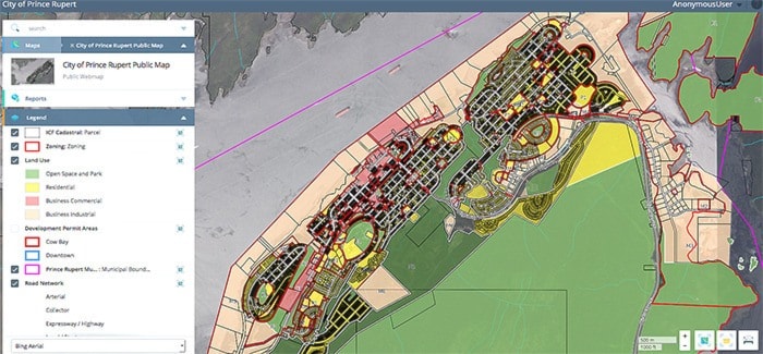
The City of Prince Rupert released a scaled-down version of its Geographic Information System (GIS) last week that can be used for informational purposes.
Launched at the special council meeting on March 9 and uploaded to the city’s website, the digital map of Prince Rupert allows residents to view land-use and zoning designations, development permit areas, along with the city’s road network and main waterline.
The city received an $80,000 Northwest Readiness Grant through the Northern Development Initiative Trust to translate all of its data into a GIS platform, contracting Urban Systems for the undertaking.
The database consists of information from the various city departments, which will continue to be updated from now on.
“This will take us from having the information on papers scattered through multiple departments to one central computerized system that overlays it over a map of Prince Rupert and clearly displays it to us,” said Prince Rupert Mayor Lee Brain.
“This is one central database that our staff will be able to quickly and efficiently get information for developers or people applying for a rezoning. It’s really going to help with efficiency.”
The city has been using an internal version of the GIS for a couple of months, which also maps out city infrastructure such as water and sewer lines, has property ownership details and includes the information gathered during the recent housing and land-base inventory studies. Brain said eventually there will be more information added onto the public GIS.
Part of the planning for major projects initiative, Prince Rupert’s GIS will assist both the city and companies looking to develop major industry in the community in the designing phase of projects. The system allows for different scenarios to be tested out, with users having the ability to set variables and filters to determine what information is shown.
“For example, we have put in a bunch of areas that potentially could be work camp sites for LNG-related development,” Brain said.
In order to maintain the database, city staff is recommending a new position be created at city hall at a cost of about $50,000 in the 2015 budget. This proposed new employee would work half-time as GIS manager, spending the remainder of time as an information technologist.