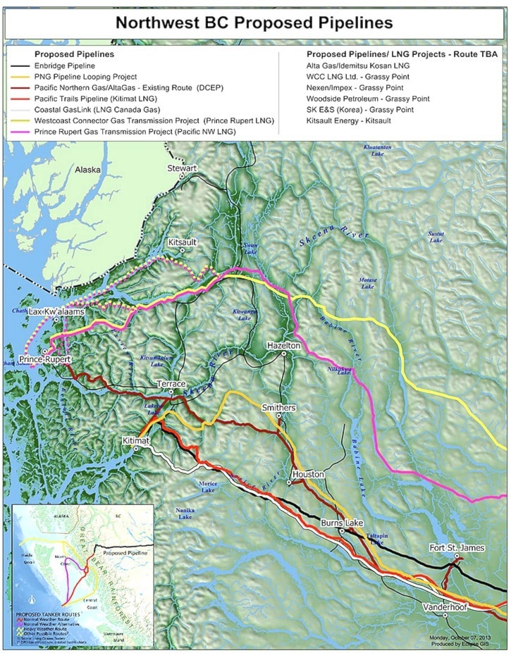
With so much interest in energy exports to serve Asian markets, keeping track of the number of pipelines proposed to move through northwestern B.C. is no easy task.
There are currently six proposals on the table to carry both liquefied natural gas, bitumen and refined oil between either Kitimat or Prince Rupert and northeastern B.C. or Alberta. Each of the pipelines would require a right-of-way running hundreds of kilometres through undeveloped crown land, but each represents a multi-billion dollar investment and millions of dollars in taxes paid to government.
But the reality is that without pipelines, none of the energy projects proposed for the region can happen and the jobs supported by upstream exploration would be at risk as producers find a way to get their product to market.
The following is a snapshot of pipeline activity in the Northwest.
Enbridge Northern Gateway
The farthest along of all the pipelines proposed in the region may also be the most well known of them all.
Enbridge is proposing to construct twin 1,177 kilometre pipelines from just outside of Edmonton to a deepwater terminal in Kitimat. The oil pipeline would carry 525,0000 barrels of oil per day from Edmonton to a Kitimat marine terminal that includes two mooring berths and 19 storage tanks.
Following three years of community consultations, the Enbridge Northern Gateway Joint Review Panel recommended approval of the $6 billion project on Dec. 19, 2013. The decision now rests with the Federal Cabinet, who have six months from the tabling of the panel’s report to approve or reject the project. Should the government grant approval, construction would begin later this year with operations commencing in 2018. During the construction period, 3,000 construction positions and 62,700 person years of employment would be created.
The pipeline would run north of Hwy 16 and cross it near Burns Lake, would cross Hwy 27 south of Fort St. James and cross Hwy 37 between Kitimat and Terrace.
Coastal GasLink Pipeline
Serving the proposed LNG Canada terminal, the Coastal GasLink Pipeline is one of two planned for construction by TransCanada Pipelines.
The 650-kilometre pipeline would begin in Dawson Creek and connect to Kitimat, crossing Hwy 27 midway between Vanderhoof and Fort St. James and crossing Hwy 16 just west of Fraser Lake. The initial capacity of the 48-inch pipeline would be 1.7 billion cubic feet of gas per day.
An application for an Environmental Assessment Certificate was filed with the B.C. Environmental Assessment Office on March 12, 2013 and the project description was filed with the Canadian Environmental Assessment Agency in October, 2012. Pending approval, construction is scheduled to being next year with operations beginning in concert with the Kitimat LNG terminals coming online.
The cost of the project is estimated to be $4 billion and TransCanada anticipates up to 2,500 direct jobs will be created during the two-to-three year construction window.
Pacific Trails Pipeline
Kitimat LNG partners Chevron Canada and Apache Canada each own a 50 per cent stake in the Pacific Trail Pipeline, which will serve their planned terminal at the end of the Douglas Channel.
The pipeline would tie into existing Spectra Energy infrastructure at Sumit Lake resulting in a length of approximately 460 kilometres. The pipeline would follow a similar route to the Coastal GasLink project, crossing the highways at similar points, but unlike the other LNG pipeline would also cross Hwy 37 between Terrace and Kitimat.
Because of the shorter length of the 42-inch diameter pipeline, which would have a capacity of 1 billion cubic feet per day, the project is expected to cost approximately $1.5 billion
Prince Rupert Gas Transmission
The second pipeline to be constructed by TransCanada Pipelines, the Prince Rupert Gas Transmission Project will feed the Pacific NorthWest LNG terminal proposed on Lelu Island.
The 900-kilometre pipeline would run north of Hwy 16 for the entirety of the route, crossing Hwy 37 at the Cranberry Junction and heading toward Nisga'a territory. There are two possible routes still being considered from there. The first would completely avoid Nisga'a treaty lands, running north and entering the marine environment just south of Alice Arm. The second would run through the Nisga'a territory, mirroring Nass Road and entering the water near Kincolith. Regardless which route is taken, the submerged pipeline would make its way around Grassy Point and down past Digby Island before connecting to the terminal at Lelu Island.
The company hopes to apply for regulatory approval for the $5 billion project in the coming months and begin a two-year construction period in 2015. The goal is to have the pipeline operational in 2018 to coincide with the commencement of operation of the terminal.
Once complete, the pipeline would have an initial capacity of 2 billion cubic feet of gas per day with a maximum capacity of 3.6 billion cubic feet per day.
Spectra Energy Pipeline
A 50/50 partnership between the BG Group and Spectra Energy, plans are in place for an 850 kilometre pipeline between Cypress just south of Fort St. John and Ridley Island in Prince Rupert to serve the BG Group's proposed terminal.
The pipeline will run north of Hwy 16 to Cranberry Junction where it will cross Hwy 37.
The 850 kilometre, $6 billion pipeline will include pipe between 36-inches and 48-inches in diameter with a capacity of up to 4.2 billion cubic feet of gas per day. The project is expected to create between 3,000 and 3,600 person years of employment during construction and between 50 and 60 permanent jobs.
Spectra Energy anticipates filing the environmental assessment for the project later this year and anticipates moving gas to Ridley Island in 2019.