The Prince Rupert Back-Country Society is looking to develop "a long-term trail network plan" to connect Prince Rupert with the surrounding area on Kaien Island for walking, hiking and biking usage.
The ambitious plan, as outlined by secretary and treasurer of the Back-Country Society Steve Milum, is meant to be aligned with the City of Prince Rupert's Quality of Life Community Plan. It will include six areas within its proposed construction, as reported in the Kaien Island Trail Plan Proposal developed by the board of directors.
"We're basically moving forward with it. We've got over half our funding in place and we're waiting to hear back from a couple other potential partners," said Milum.
The first item is a trail route design "that serves the community at large that not only meets all property owner requirements but also makes them want to be a part of the initiative," the society's report states.
Subsequent items include proposals for rest stops, points of interest, interpretive signage, brochures/maps, alternative activity junctions and marathon routes of various lengths as well as listing the benefits and potential liabilities to the building and usage of the trails.
Other components that are part of the proposal seek out estimated costs for building and maintaining the trails, options for financing and building the trail network and clarification on the rights and responsibilities for property owners and users.
"Engagement has pretty high ... we've recently submitted several applications and we've been getting good responses so far [from potential fund providers]," said Milum.
The biggest obstacles to these types of initiatives in the past, states the proposal, is the various stakeholders who have claim to the lands needed for the network and the costs associated with the plan. The Province of B.C., the federal government, corporations, First Nations groups and private owners all hold stake in the lands the group is interested in and the society recognizes the urgency they face with interested industry and investment corporations looking to purchase nearby property in the near future.
"Our objective is not to simply claim valuable land before someone else does, but to designate some areas for community use so that other development can exist around these areas without conflict," the proposal states.
The society is looking to hire a consultant to assist with the negotiations and land-plotting needed to map the routes. The consulting firm will be chosen once the funding has been collected, stated Milum.
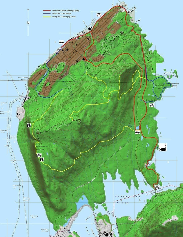
The trail network has been devised into three routes: A main access route, for walking and cycling and two hiking routes – one with a higher difficulty level than the other.
On the map to the right, the blue route indicates a low-difficulty hiking trail, the yellow is a high-difficulty trail and the red is a main access route.
The plan proposes to access the Butze Rapids hiking trail, the Oliver Lake picnic area, the Grassy Bay shoreline and the Galloway Rapids bridge from downtown Prince Rupert "without using the highway, main roads, sidewalks or shoulders".
The hiking trails extend through the higher elevation levels of Kaien Island to run a loop around Mount Hays.
Milum and the board of directors expect the planning process of the project to cost $35,000 and to include 12 weeks to clear the hurdles necessary to transition to the public feedback stage. The society hopes to have all their funding in place and to start the work-plan by late September, which Milum said would enable the group to complete their rough-outlined 12-week feasibility process by the new year.
The process would include route-finding, setting and flagging, meeting with any and all title-holders and stakeholders to overcome any issues or concerns they may have with building the network of trails, GPS mapping, drafting an archeology study and report and making revisions to the conclusive reports by the 12 weeks' end.
A final presentation would then be made to the public and media.
A lack of land-based recreational activities, including a trail network and beachfront property due to industrial zoning, has been a topic of concern for residents in recent years.